Recent Earthquakes in California and Nevada
Los Angeles Special Map
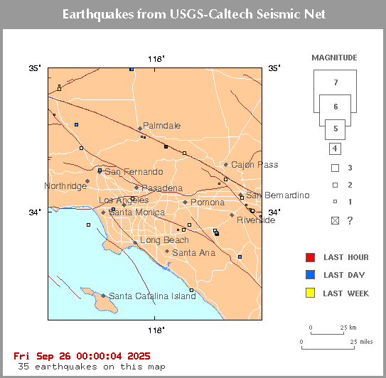
Click on an earthquake on the above map for more information.
Update time = Sun Jul 5 07:00:01 2026
Here are the earthquakes appearing on this map, most recent at top ...
| MAG | LOCAL DATETIME y/m/d h:m:s |
LAT deg |
LON deg |
DEPTH km |
LOCATION |
| 0.5 | 2026/07/05 06:28:16 | 33.902N | 117.321W | 7.40 | 4 km ( 2 mi) ENE of Woodcrest, CA |
| 1.4 | 2026/07/05 02:55:58 | 33.383N | 117.612W | 14.27 | 5 km ( 3 mi) S of San Clemente, CA |
| 1.8 | 2026/07/04 21:20:01 | 34.774N | 118.335W | 19.31 | 13 km ( 8 mi) NNE of Elizabeth Lake, CA |
| 1.5 | 2026/07/04 21:16:31 | 33.717N | 117.420W | 16.27 | 10 km ( 6 mi) WNW of Lake Elsinore, CA |
| 1.4 | 2026/07/04 21:14:10 | 33.564N | 117.637W | 11.29 | 1 km ( 0 mi) S of Ladera Ranch, CA |
| 1.5 | 2026/07/04 21:09:54 | 34.279N | 117.994W | 20.83 | 14 km ( 9 mi) NNE of Sierra Madre, CA |
| 1.5 | 2026/07/04 21:07:11 | 33.877N | 117.655W | 14.17 | 8 km ( 5 mi) W of Corona, CA |
| 1.1 | 2026/07/04 21:03:40 | 33.919N | 117.739W | 29.10 | 8 km ( 5 mi) ENE of Yorba Linda, CA |
| 1.0 | 2026/07/04 18:46:32 | 34.008N | 117.207W | 15.89 | 6 km ( 4 mi) SSW of Redlands, CA |
| 0.8 | 2026/07/04 04:27:21 | 34.406N | 118.565W | 4.74 | 5 km ( 3 mi) S of Valencia, CA |
| 0.5 | 2026/07/04 02:46:10 | 33.982N | 117.154W | 9.68 | 9 km ( 5 mi) SSE of Redlands, CA |
| 0.8 | 2026/07/03 23:09:44 | 34.255N | 117.236W | 21.15 | 4 km ( 3 mi) W of Lake Arrowhead, CA |
| 0.6 | 2026/07/03 20:30:06 | 34.001N | 117.219W | 4.59 | 6 km ( 4 mi) SE of Loma Linda, CA |
| 1.5 | 2026/07/03 19:30:12 | 33.813N | 117.670W | 4.47 | 11 km ( 7 mi) SW of Corona, CA |
| 1.0 | 2026/07/03 16:44:57 | 34.196N | 117.438W | 9.81 | 4 km ( 3 mi) SW of Devore, CA |
| 1.4 | 2026/07/03 15:07:02 | 34.507N | 118.830W | 2.59 | 11 km ( 7 mi) NNW of Piru, CA |
| 1.2 | 2026/07/03 09:54:20 | 34.639N | 117.306W | -0.69 | 11 km ( 7 mi) NE of Adelanto, CA |
| 0.8 | 2026/07/03 07:35:55 | 34.031N | 117.204W | 12.34 | 3 km ( 2 mi) SW of Redlands, CA |
| 1.4 | 2026/07/03 07:30:18 | 34.142N | 118.365W | 16.21 | 1 km ( 1 mi) WNW of Universal City, CA |
| 0.9 | 2026/07/02 20:48:33 | 34.955N | 118.481W | 2.31 | 20 km (12 mi) S of Tehachapi, CA |
| 1.0 | 2026/07/02 15:20:03 | 34.039N | 117.244W | 16.13 | 2 km ( 1 mi) SE of Loma Linda, CA |
| 1.4 | 2026/07/02 11:57:36 | 34.986N | 118.188W | -0.82 | 3 km ( 2 mi) SSW of Quarry at TPO-DBM (Probable quarry explosion) |
| 1.7 | 2026/07/02 11:37:20 | 33.849N | 117.493W | -0.50 | 1 km ( 0 mi) E of Quarry at CORONA (Probable quarry explosion) |
| 1.5 | 2026/07/02 11:07:10 | 33.820N | 117.487W | -0.64 | 4 km ( 2 mi) SSE of Quarry at CORONA (Probable quarry explosion) |
| 1.4 | 2026/07/02 10:00:04 | 34.022N | 117.590W | 5.05 | 5 km ( 3 mi) SE of Ontario, CA |
| 1.5 | 2026/07/02 07:14:19 | 33.587N | 117.895W | 13.26 | 5 km ( 3 mi) SE of Newport Beach, CA |
| 1.0 | 2026/07/02 06:29:31 | 34.120N | 117.598W | 11.03 | 2 km ( 1 mi) W of Rancho Cucamonga, CA |
| 1.4 | 2026/07/01 15:16:27 | 33.713N | 117.333W | -0.53 | 21 km (13 mi) NE of Quarry at ELS (Probable quarry explosion) |
| 0.9 | 2026/07/01 12:47:46 | 33.843N | 117.770W | 6.98 | 5 km ( 3 mi) NE of Villa Park, CA |
| 1.3 | 2026/07/01 12:29:21 | 34.181N | 117.924W | -0.91 | 22 km (14 mi) NNW of Quarry at POMONA (Probable quarry explosion) |
| 1.0 | 2026/07/01 10:28:22 | 34.957N | 118.602W | 8.57 | 20 km (12 mi) N of Neenach, CA |
| 1.1 | 2026/07/01 09:27:52 | 34.022N | 117.204W | 13.13 | 4 km ( 3 mi) SSW of Redlands, CA |
| 0.5 | 2026/06/30 23:13:46 | 34.114N | 117.477W | 6.65 | 2 km ( 2 mi) NW of Fontana, CA |
| 1.2 | 2026/06/30 19:34:18 | 34.407N | 118.617W | 6.17 | 7 km ( 4 mi) SW of Valencia, CA |
| 1.3 | 2026/06/30 12:00:57 | 34.980N | 118.175W | -0.82 | 3 km ( 2 mi) S of Quarry at TPO-DBM (Probable quarry explosion) |
| 0.8 | 2026/06/30 04:29:54 | 34.151N | 118.370W | 15.75 | 2 km ( 1 mi) NW of Universal City, CA |
| 0.5 | 2026/06/28 23:49:36 | 34.011N | 117.215W | 6.87 | 6 km ( 4 mi) SSW of Redlands, CA |
| 0.8 | 2026/06/28 17:59:10 | 34.148N | 118.370W | 16.18 | 2 km ( 1 mi) NW of Universal City, CA |
| 0.9 | 2026/06/28 15:29:13 | 34.142N | 118.341W | 16.12 | 1 km ( 1 mi) ENE of Universal City, CA |
[
Index map ||
Big earthquake list ||
All earthquake list ||
Glossary of terms ||
Top page
]
[
Did you feel it? ||
ShakeMaps
|| Relative2Me
]
[ Data Sources ]
Special maps
Long Valley || Los Angeles || San Francisco
Data Sources
US and World - USGS/NEIC = National Earthquake Information Center
Northern California - UCB = University of California, Berkeley
Southern California - Caltech = California Institute of Technology
Nevada - UNR = University of Nevada, Reno
Offshore = West Coast & Alaska Tsunami Warning Center
...all members of the Advanced National Seismic System (ANSS)