
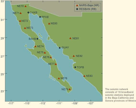
The NARS-Baja seismic network was established to provide broadband recordings in the region surrounding the Gulf of California, an area of active continental rifting. The goal is to understand how the rifting process couples to the underlying mantle.
The Baja part of the network was first operational in April of 2002, and the Sonora part was added in November of 2002. It is funded to continue operations until April of 2007. The project as initially funded by the Margins Program of NFS (USA) under the award EAR-0111650. Continued operational support is provided under the NSF/Margins program under award EAR-0405437. The RESBAN data is provided courtesy of CICESE.
The instruments are broadband STS-2 sensors and a custom recorder build by Utrecht under the NARS program. Three-component BH (20 sps) and LH (1 sps) channels are recorded. These stations recorded locally on site, and the data are retrieved approximately every 3 months. The RESBAN array uses CMG 40T sensors.
CICESE
Ensenada, Mexico
Cecilio Rebollar
University of Utrecht
Utrecht, The Netherlands
Jeannot Trampert
Hanneke Paulssen
Caltech
Pasadena, USA
Robert Clayton

The data are archived at both the IRIS- DMC and the SCEDC (Southern California Earthquake Data Center). The network code for the NARS-Baja network is NR.
To check for data availability on the SCEDC site, click here.
A tutorial on retreiving the waveforms from the SCEDC is available here.
The details of the stations are given in the Table of Stations.
Topographic Map
Larger Scale Map
The NARS-Baja Seismic Array in the Gulf of California Rift Zone (PDF)
Google Earth